Weather was reasonable today, so I packed some sandwiches and my camera and my walking boots, and drove off to Kilsyth. My intention was to get a better idea of the area of the battlefield to the north and east of the [modern] Banton Loch. Here's an annotated aerial view, courtesy of Google Maps and Paintshop Pro.

I've added the initial positions of the armies, as I understand them, a couple of extra place names, and the asterisks show the scope of my walk. North is at the top. A very quick resumé of the build-up to Kilsyth:
William Baillie's Covenanter army had been well beaten at Alford, and Montrose took the opportunity to head south, for the Lowlands. The Scottish government were terrified he was going to make for Edinburgh, but that city was plague-bound, and Montrose headed for Glasgow, via Stirling. Baillie followed, but was delayed by a number of issues, not least being the fact that he had to wait for someone to round up three Fife regiments which had decided to head for home. By the time the Covenant forces got onto our map, Montrose's troops had been camped on an elevated "meadow" in the Valley of the River Kelvin for a day or so, overlooking the road from Stirling to Glasgow, waiting to spring a nasty surprise on Baillie and friends.
[Please note that the village of Banton, the reservoir of Banton Loch and most of the roads apart from the Stirling road at the bottom did not exist until some time after 1645]
Baillie had the additional burden of having with him the chiefs of the Committee of Estaits (Argyll and others, whom Gardiner's history describes as having "a grasp of strategy proportional to their ignorance"). His scouts realised the Royalist army was waiting for them, so Baillie agreed with his "advisors" that his troops would leave the road, taking up a position on Montrose's flank, concealed by some rough ground. Baillie knew that the Earl of Lanark was coming from the West with a reinforcement of 1500 men for him (described as "tenants of the Hamiltons"), and appears to have been prepared to wait in this position until Lanark arrived. What he did not know (though Montrose, it seems, did) was that Lanark was only about a day's march away.
The political whizz-kids were keen that Baillie should attack Montrose's flank straight away. Baillie was convinced that the rough, rising ground to his front made such an attack impossible, so his counter-proposal was that he should face his troops to their right, and march them in column up to high ground at Auchinrivoch, where they would be above Montrose's left rear. This was agreed, so off went his column, with (I think) Balcarres' cavalry in the front, followed by a converged unit of commanded shot commanded by a Major Haldane, then Robert Home's veteran regiment of Foot, and the rest strung out, with the unhappy boys from Fife at the rear.
It's quite a pull up the hill (I did it today); it might have been a fair plan, but they didn't make it. Well, Balcarres' Horse might have, but the commanded shot and Home's regiment spotted some Highlanders occupying an area of enclosures at Auchinvalley, and headed west to attack them.
Thus the Battle of Kilsyth becomes, in effect, an encounter-type action. Montrose's army was rushing to its left flank, to face an attack coming from that direction, and Baillie was forced by the actions of his subordinates to form into an improvised battle line on rough ground, well short of (and lower than) the position he had intended. The subsequent progress of the day is for another post, or maybe for a game, so I'll return to the story of my scouting trip now.
I parked in Banton, near the Swan pub, at the crossroads, with the intention of walking up towards Auchinrivoch and Auchinvalley, to get some photos of how the land lies. Before I started, I spoke to a couple of residents, who were interested to know what this strange chap with hill boots and a stupid hat was doing in their village on a quiet Bank Holiday. I asked to check my directions for Auchinvalley - no-one had heard of it. They knew of Auchinrivoch - there is a farm there - but otherwise all places are known by who lives there. They wanted to know was it the Hendersons' place. Obviously I had no idea - and I certainly don't know who lived there in 1645. However, they were very kind, and got me on my way, and it isn't a very obvious track!


The oldest building I spotted was the one on the left, which was built in 1811 and rebuilt in 1845 (create your own story here).


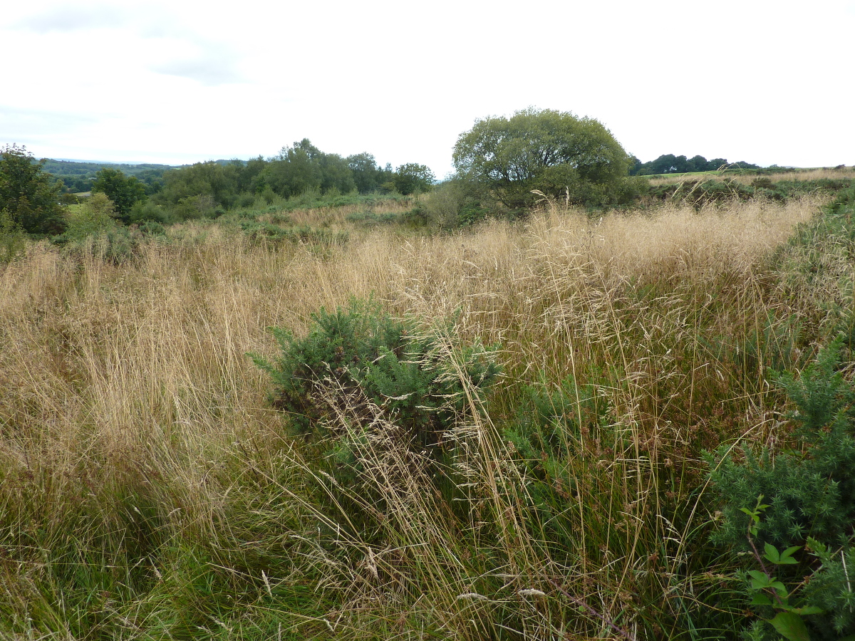


Interesting. Tricky terrain. Lots of dead ground. Imagine trying to keep in order and then a bunch of hairy arrised highlanders come screaming at you out of nowhere.
ReplyDeleteThe ground is very broken up into hillocks and gullies by the many burns, and the hill which hides Baillie's flanking manoeuvre can also hide a potential ambush which is waiting for them! It seems (from a few sources) that the Covenant command (well, not Baillie, but the politicians and the leaders of odd units) were convinced that Montrose's lot were retreating to the west, so there may have been some very nasty surprises on the day. As far as i can work out, the highlanders were on Montrose's left flank in the initial configuration, with the Irish in the centre and the Scottish "regulars" (Strathbogie etc) on the right, so when they ran to their left they would arrive in exactly the order that you wouldn't wish to meet them. In my game the highlanders don't have any firepower - I realise they did have some, but I've assumed it was so disorganised that it just assumes the same effect and range as sticking a sword in someone.
DeleteThat's the problem with battlefields in the UK somebody has always built on them or mucked them about - I once took my wife to see the site of Prestonpans - I draw a veil over the sad event (she was not impressed) (sadly neither was I )
ReplyDeleteIt's a while since I was there, but I thought Prestonpans might be one of the better surviving examples, but if your wife was not impressed then fair enough! Not easy to think what might what else might happen to the old battlefields, and how far back we go, and which political causes are now considered worthy of preservation. It occurs to me that, once upon a time, Big Oswald hit Fat Gilbert over the head with a stick in your very garden, in an argument about whose turn it was to repair the fence. You could open your garden to tourists, with a visitor centre and all that, as long as it was a sufficiently important fence.
DeleteYou are, of course, quite correct - my mind was just wandering. I realise it's a stupid idea - unless we could charge the beggars a couple of quid each to get in...
I found your photos most interesting, thanks for posting them. An addition of a village and a loch to a battlefield is rather extreme when trying to visualise the past. I wonder if it a record for change in a battlefield over time?
ReplyDeleteInteresting point. The locals were (all except one) convinced that the battle of Kilsyth took place underneath the loch, which sort of consigned it to some shadowy pre-history. This is an impression which is sustained by the fact that Colzium House (western end of the loch) has a monument to the battle - if Montrose's original ambush had succeeded then the location would be fairly close! The one villager with a different view was a retired teacher, as it happens, and she was aware that the contemporary accounts by participants on both sides (Baillie and Wishart) both place the battle where I took my walk.
DeleteI guess space has always been at a premium on such a small island as Britain, and building council housing estates and so on has always been a feature of the subsequent loss of sites. Of the top of my head, I would guess that the Victorians planting a forest on the Culloden site, to obliterate it and prevent its becoming some sort of Nationalist shrine, must be pretty hard to beat!
Both Newbury battlefield sites have been extensively built on Alan. As has Brentford. The non-battlefield of Turnham Green has completely disappeared under urban development apart from a tiny strip of park. Edgehill has an MID facility slap bang in the middle, to use an appropriate sounding phrase.
DeleteFurther afield, and a century later, Chotusitz (1742) has an airfield on it. The old Czechoslovak airforce I think.
Interesting day out for you, though I am surprised you did not partake of the refreshment om offer at The Swan (a very English sounding name for a Scottish pub, in my opinion!) look forward to seeing how the TEWT is translated onto your wargaming table
ReplyDeleteI understand there are swans on the (artificial) loch, which might give us a clue! When I visited Marston Moor I was on the bus from York, so lunch at the pub in Tockwith was a necessary part of the trip; yesterday I arrived at about 9:30am, and, though I left around 1:30pm, I had about 90 minutes drive on Scottish motorways coming up, so I was - literally - on the wagon. Perhaps I should go again and visit Colzium...?
DeleteThe terrain had always puzzled me - how best to set up the table, and which kicking off point to choose to make it all viable? I now have a much better idea of the actual ground, and the lightbulb moment has been that I now propose to rotate the battlefield through 90 degrees on the tabletop. I have decided that the encounter I have envisaged, rather than the initial positions and some strategic countermarching, should be the core of the game. This is completely different from my solo game from 2014!
Always strikes me when you look at 'real' battlefields how little we take into account the difficulty of the terrain. Can you imagine trying to keep anything in order amongst that scrub? Would play havoc with the neat boxes you see on battle maps or of our wargames units.
ReplyDeleteThanks for this - impressive. I once got to Kilsyth, but was pressed for time so only got to see it from the wrong side of the loch from where, obviously, you can't see a blind thing.
Hi Chris - very true. If you look at the aerial photos it all looks a bit like parkland, but the close-up reality is something of a shock! It looks as though Baillie only refused to make the direct flank attack once he had reached the ground where the attack was to take place, and realised the difficulty he would have.
DeleteAhh battlefields! 20 years ago, having recently visited Gettysburg in the US where the battlefield had been turned into a National monument while there were still veterans of the battle to consult and there are markers for where leaders fell and where each regiment was posted etc etc, I made a trip to Ontario to visit a few War of 1812 battlefields. hmmm
ReplyDeleteAt Queenston Heights, the one battle that most people have heard of, there is the big monument to General Brock, the dead hero, in a big park with a nice view but where the fighting was and a walking trail through the woods, which didn't exist in 1812, with occasional markers saying things like: we think the British battery was here...or maybe over there, down here, or over there somewhere was where the Americans landed..... and somewhere over that way was probably where Brock was shot. Then there was Chippewa with a nice little park with a map posted at 90 degrees to the ground it shows, trusting that you can figure that the open battlefield the map shows ahead of you, is actually the area now covered in trees to your left while the woods shown to the right are actually that farmers plowed field ahead of you.....
I had a similar experience at Abensberg a few years ago - great historian gave us a personal tour of the field, with a minibus and everything, but a lot of the action is almost impossible to envisage, since there's a modern garden centre, or the wood where the Bavarian skirmishers were placed has moved half a mile since 1809.
DeleteGreat insight into the field of battle, very interesting. The opportunity to walk a battlefield should always be taken if possible, even where there’s been some development there’s a lot that can be gleaned from a visit.
ReplyDeleteI agree, but it is something I haven't done a lot of. Big benefits from doing plenty of reading in advance, and deciding what you want to look at, and how to get there, though I suppose there is a risk that you may choose not to look at something you should!
DeleteA very enjoyable tour - thank you! It sounds like your trip was worthwhile. Looking at the photos, I can well imagine the Baillie’s battle plans unravelling on that terrain as more and more troops were sucked into the fighting. It must have been pretty chaotic on both sides. No wonder Baillie never got to use his guns, although that was an interesting bit of local knowledge about the cannonball find. Living as nearby as I do, I’m ashamed to say I’ve never walked those fields, although I have cycled home from Kilsyth to Stirling via the Tak Ma Doon road several times and can well attest to the steepness of those hills. It will be interesting to hear how your own scenario plays out. An interesting ‘what if’ would be the arrival of Lanark’s reinforcements from the west. Speaking of battle sites from that era, I coincidentally happened upon the memorial cairn to the 1651 Battle of Inverkeithing a few weeks ago whilst visiting my mother in Dunfermline. Compared to that, the Kilsyth battlefield looks positively unspoiled. I didn’t explore the area properly mind you, so there might be something among the sprawl of roads and houses to merit another roving report.
ReplyDeleteKevin
Hi Kevin - thanks for this. I'd like to have spent a bit of time looking at the western end of the loch, but it was raining by that stage, and I have photos of that in my books and online, so I called it a day. The fact that everything is privately-owned land makes access a bit tricky, and there were some frisky looking bullocks that kept me out of a couple of fields!
Delete...and if you cycle up the Tak-ma-Doon road then you have my respect!
DeleteMost interesting, thanks! Sorry to see the holiday weather for you was no better than the gloomy weekend we had 'dahn sarf'..
ReplyDeleteFor us, this wasn't bad. At least I got a dry few hours in the middle of the day for my recce trip. I'm thinking of changing my battlefield plan to say "Henderson House" and "Walpole House" - like the ACW! I also asked the villagers if they could identify Slaughter Howes, Bullets Howe, Baggage Knowe, and other local names for the hills, which my reading assures me were adopted after the battle - you guessed: no-one had ever heard of any of them - blank looks all round!
DeleteI enjoyed your personalized battlefield tour, Tony. Thank you!
ReplyDeleteMy considerable pleasure Jon! I've visited my chiropractor since Monday, and he confirms that all the bits are still in the right places!
DeleteA splendid piece of battlefield detective work. It all looks relatively unspoiled and quite charming. Also grateful that you explained the battle because that whole period is an absolute blind spot in my British history. I know Steeleye Span or Old Blind Dogs or someone did a song about Montrose but that's about it. Lovely post.
ReplyDeleteThank you Mike - the tough thing to get your head around here is that, Civil War or not, this particular capaign has very little to do with King Charles I - it is mostly about the MacDonalds vs the Campbells, with the Gordons piling in on the MacDonald side! Highlanders apart, there was also a lot of resistance to the Scottish goverment in Aberdeenshire, and that must all be about family and regional feuds as well!
Delete