Napoleonic & ECW wargaming, with a load of old Hooptedoodle on this & that


Showing posts with label Walking. Show all posts

Tuesday, 25 December 2018

Hooptedoodle #318 - Unfamiliar Birds

Very quiet day here - grey and overcast. The Contesse and I went for a walk down by the River Tyne (as discussed previously, this is the Scottish Tyne, not the one that goes through Newcastle). Very quiet down there - maybe people are put off by the muddy conditions? We did see a couple of birds which we didn't recognise - since we didn't have a camera with us these are not our photos, but these are definitely what we saw - library photos courtesy of the RSPB, which is where we get our knowledge of birds anyway!

White-Throated Dipper
Goosander - male on the right
We walked along the river to the footbridge next to Hailes Castle, crossed over and back to the village of East Linton by (very quiet) public roads to reclaim our car. Good walk - only about 4 miles, but stimulating on a cold day.

The narrow bridge over the Tyne at the village of East Linton - until 1927 this was part of the A1, main road from Edinburgh to London!
Hailes Castle - another seat of the Hepburn family, I think - can't move for history round here!

Saturday, 14 July 2018

Hooptedoodle #306 - A Rumination on the Other River Tyne

Hailes Castle
Yesterday the Contesse and I went for a pleasant walk along the River Tyne. We started at the village of East Linton (which was once quite an important toll-bridge crossing on the road from Edinburgh to London), walked upstream along the river bank for a couple of miles until we reached the first footbridge, crossed over to Hailes Castle, then walked back along the public road (more of a track really) into the village to collect our car. Very enjoyable, and an easy walk to suit a rather humid day.

Some photos from yesterday's walk - the water level is quite low, with the current
dry spell, and these streamers of weed and algae are not what we normally see

View from the footbridge at Hailes

The bridge on this new (2003) section of the A1. Traffic running between the capitals
of England and Scotland sweeps over the valley of the Scottish Tyne without even noticing.
Everyone knows of the River Tyne. It is a major river on which stands the mighty city of Newcastle, and it has a long, hardworking tradition of shipbuilding. When we mention that the River Tyne is near us, visitors assume we must live close to Newcastle (which is about 100 miles away - 2 counties away), or that we must mean the North Tyne (which runs into the Northumberland Tyne, and is also a long way from here), or that we must be mistaken (no comment on that one), or that the Scots are obviously so bloody stupid that they have named a river after a more famous one which is not so far away, or that by some peculiar coincidence the rivers were independently given the same name.

The last of these is probably closest to the facts, but I've always been intrigued that the situation exists. So I did a little (trivial) research, and I find that these rivers have existed, within a hundred miles of each other, with the same name for a very, very long time. Hmmm. Our River Tyne, you see, rises somewhere to the west of Pencaitland (a town most famous these days for the manufacture of Glenkinchie whisky) and flows 30 miles through the county of East Lothian, passing through the county town (Haddington), then through East Linton, and Tyninghame (yes, yes, that's right), emerging into the North Sea somewhere between North Berwick and Dunbar.

River Tyne at Haddington
So why "Tyne"? In fact the answer is laughably simple, and I'm sure you either know or have guessed the truth already. Both rivers appear to get their name from an ancient word, tin, meaning river. This may be Brythonic, or may be some older, pre-Celtic word, but neither of our rivers seems actually to have been known as Tyne until Anglo-Saxon times. Interesting. Gradually, the word for river is handed down from a defunct language until, by default, it becomes the name of the river. One imagines some medieval incomer - maybe a tourist or some sort of bureaucrat from whatever new lot are taking over - and he asks, "what's this, then?", and the locals say, "oh, that's the river" - in fact, they may already be using the old word as a name, without realising - and the newcomer takes note that this is what the river is called.

This must have been fairly common. The River Avon must also, I guess, be named "river"; certainly the modern Welsh word afon is a close relative, you would think. So I am building a picture where the unsophisticated locals, who didn't have that many rivers to worry about, just called the thing "the river" in their own language, and eventually the language changed but the name had stuck.
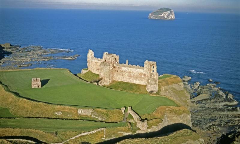
Tantallon
It doesn't necessarily suggest a lack of creative imagination - they must have had other things to worry about; coming up with some more decorous (or pretentious) name for the river might have seemed unnecessary. Locally, we have another example of this sort of thing. Next door to the farm where I live is the ruin of an ancient seat of the Douglas family, Tantallon Castle, on which topic I have posted before. "Tantallon" has a splendid, wild sound - in keeping with the rugged appearance and setting of the place. The name, however, has a fairly mundane pedigree. Around 1300, it is referred to on a map as "Dentaloune", and later in the same century the Earl of Douglas writes of his castle at "Temptaloun", and both these names are now thought to come from the Brythonic din talgwn, meaning "high fortress". So the romantic Tantallon just means "big castle" in an older language. Right. That could be disappointing, but I find it interesting enough as it stands.

I'd like to leave the last word with one of the greatest 20th Century philosophers - possibly the greatest: Gary Larson.


Sunday, 3 September 2017

Hooptedoodle #274 - Opening of the Queensferry Crossing


An exciting day out for all the family - we were invited to attend the opening weekend of the new Queensferry Crossing - the road bridge across the Firth of Forth which is to supplement the Forth Road Bridge, which itself was opened in 1964 and is starting to show its age.


When I say invited, a few months ago there were adverts in the Press, inviting applications from the public to walk across the new bridge when it was opened, before the traffic started. Some one-third of a million applications were received, and a ballot reduced this to 50,000 attendees, divided into the two open days, 2nd and 3rd September. We were lucky enough to be allocated places on the 3rd, so we went along this morning. The security arrangements were impressive - passports and photo-ID were needed, and all applications were carefully vetted. Limitations were placed on what you could carry, and all bags and possessions were checked. Our plan of action was

(1) Early morning train from North Berwick to Edinburgh Waverley, then take the Stirling train as far as Edinburgh Park (only two stops, in fact).
(2) From this station - out in the suburban world of banking head offices [boo!] - it was about 10 minutes walk to our official bussing point.
(3) Through all the security and registration procedures, and then onto a brand new bus (no expense spared) and a 25 minute run to the southern end of the new bridge, near the town of South Queensferry.

We then were free to join the crowds walking over the new bridge. A marvellous experience - we were very lucky with the weather, too. There were people in fancy dress, raising money for charity, folk in wheelchairs - many thousands of visitors - a great day out for all. The numbers are bewildering - the bridge is 1.7 miles in length, and it cost some £1.35bn - there are also endless statistics about how much concrete was required, how many people worked on it, how much traffic it will carry, and so on and so on - if you are interested, please check online - there's tons of the stuff (I won't tell you how much...). We took about an hour to walk across - taking our time and capturing a great many photos - and then were taken by bus back to Edinburgh Park, from whence we started our train trip home.

Excellent. Also it was free to the participants, and this is really quite a production - I guess that a portion of the project budget is set aside to ensure that the taxpayers are happy with the thing.

What was it like? Well, it was great, but a little odd. I have to say that I was surprised that there was not a great sense of being on a big bridge over an arm of the sea. If this seems a strange thing to say, it is probably a testament to the skill of the design. The superstructure is only in evidence if you look up (and it is most certainly very much in evidence then!), and the transparent windbreak panels cut down on both the view and the breeze, so the overall impression is of being on a straight piece of modern roadway.

I've reproduced a selection of our photos, and have added some borrowed from the media, to give a better context, and a better idea of what the thing is like - when you are on it, there is surprisingly little to see of it!

Strangely foreshortened zoom-lens shot from the Guardian, rather hides the fact
that the new structure is 1.7 miles long!

Windbreaks - West Lothian coastline in the background

I have to confess to an OCD nightmare fantasy - obviously the cables go up, though
a hole in the pillar and then down to anchor into a matching socket on the other side
- what if you've nearly finished and you find you're short of a socket? - you've got
them all one out, like the buttons on the duvet - now what...?


At the end of our trip, I am now fired up to walk across the old Road Bridge, a thing which I could have done at any time in the last 50 years - it should be a rather better spectacle, and will definitely give better views of the Queensferry Crossing.

My compliments to the heroes who built this thing, and to the Scottish Parliament for arranging the open day. It will take me a little while to appreciate what I saw today, I think. It will certainly be nicer to drive across than its bumpy old uncle next door.
 

Sunday, 5 February 2017

Auldhame Castle - Boots and Old Stones


Auldhame Castle as it is today, on the edge of a cliff - view from the North West
There is no escape - relentlessly, true to yesterday's post, I dug the boots and the camera out, the thermal underwear and the weatherproof trousers, and I walked the 600 yards through the woodland from my house to Auldhame Castle. Before you ask why I have never visited the place before, I can only say that I seem to have been busy.

Auldhame Castle was a fortified house built, probably on or near the site of an earlier building (which may have been some form of religious retreat - see later), in about 1530, by Adam Otterburn of Reidhall, who was sometime Lord Provost of Edinburgh (from 1538 until his term of office was ended by the Rough Wooing), Lord Advocate to James V of Scotland and later secretary to James' second wife, Mary of Guise. Adam was murdered in Edinburgh in 1558.

Since he also had a residence at Reidhall (or Redhall), in Edinburgh, Auldhame may have been the family farm or a country seat, but it was a substantial structure. It was an L-shaped building - the North wing faced onto the cliffs over the Forth, on the East Lothian coast, and much of that is still standing and recognisable; the South-East wing has mostly disappeared - about all that remains is the entrance door.

Trouble with neighbours? - Tantallon, the seat of the "Red" Douglas family, is
just across a field and a little bay from Auldhame. Since Otterburn advised
James V on a treason charge against the Douglas household in 1528, it seems
odd that he chose to build next door to them. The field in the foreground is
called Old Adam, and it is here that the burial ground was discovered in
2005 - I had read that "Adam" was a corruption of Auldhame, but I prefer to
believe it is named after old Adam Otterburn


Entrance to the vanished South wing
This photo is borrowed from elsewhere - note the cloverleaf motif

Vaulted cellar area below the remaining building

In these parts, the ivy always wins in the end

Good heavens - could that be a ghostly hand waving - can you see it too...?

The flat area on which the house was built is bounded by a bank (and
the footings of an old wall, somewhere under the trees), built on top of a sandstone face
The ground is hard to figure out, because of the subsequent growth of the forest, the
progressive collapse of the cliffs in front of the house, building of more recent
walls and field structures and a fair amount of anti-tank defences left
over from WW2 - the beach here was a source of constant worry as an invasion site
(from Norway?)

This  is not a sandstone cliff - it is WW2 concrete!
No-one really knows when the building ceased to be used. One theory is that Cromwell's boys slighted it as part of a general reduction of defensible buildings in the area after the Battle of Dunbar, another is that it was already derelict by then, though it was not very old. Auldhame appears (as Oldham) on John Speed's map of Scotland in 1610 - there was almost certainly a village (probably of timber huts) in addition to the Castle. This has been swept away - nowadays the hamlet of Auldhame comprises a line of terraced farm cottages on the A198, and the large 19th Century Auldhame House, which has no connection with (and is half a mile from) the old Castle.

Just as a reminder, this is what it is supposed to have looked like around 1600
 - viewed from the same angle as my first photo - the cliffs were further away then!
During the time I have lived nearby, there was a major archeological dig (2005) in a corner of one of the fields of Auldhame Farm, next to the wood containing the castle. A Christian burial site and some form of religious building were examined, and after some debate it was decided that they probably dated from the 8th or 9th Century, possibly contemporary with our local saint, St Baldred, who is thought to have lived at Auldhame. St Baldred is a complex subject - if you can be bothered, I recommend you check him out on Wikipedia. Apart from surfing across to the Bass Rock on a rock, he also managed to be buried in three separate places - a tricky fellow.

Saturday, 4 February 2017

ECW - Work on Sieges, and the Distraction of Local Ruins

Within the next few weeks I intend to get out my ECW siege bits and pieces, and have a more formal attempt at a siege. One of my invited guests will be David the Cruncher, my chiropractor, who appeared in this blog a little while ago when he came here to be introduced to wargaming. In honour of his South Shields origins, on that occasion we played a game based on the Battle of Boldon Hill, which in reality had never quite been a proper battle at all, but the fact that David’s uncle lives in one of the villages on the battlefield was an overwhelming case in favour of the scenario.


My intended action this time will be "Something a Little Bit Like the Siege of Newcastle" (1644) – you will hear more of this shortly. Because of the impending presence of guest generals (and my experience of guest generals is that the beggars sometimes wish to have some idea what is going on), I am working on tidying up the rules, and writing them out in a form which might be understood by someone apart from me – in particular, all the scribbled pencil tables and post-it notes need some attention.

Anyway – I hope to set out more details of all this over the coming few weeks, including (maybe) a revised draft of the siege rules. In the meantime, I have become a little diverted by some of our local castles here in East Lothian.

It is, in any case, a topic which I find interesting, and there are a great many sites around here which have history related to the ECW. The most recent distraction came during my studies of the activities of the Covenanter Armies – I was reading about the East Lothian regiment which marched into Northumberland with Lord Leven (subsequently appearing at, for example, Marston Moor and the sieges of York and Newcastle), and it seems that the colonel and patron of this unit was Sir Patrick Hepburn, who lived at Waughton Castle.

Now I know Waughton – it is about 4 miles from where I am sitting – and I know there is a pile of old stones and the remains of a medieval doocot (dovecot, to English readers) on the farm at Old Waughton, but I know nothing about the history of the place – it really doesn’t look very interesting.

Wrong. A quick look at Andrew Spratt’s splendid website devoted to reconstructions of Scottish castles reveals that Waughton Castle was a fine thing – in fact here it is.

Waughton
So, if it was still the home of an important local family in the mid 17th Century, how has it vanished so completely? – so much so, in fact, that a reclusive old nerd like me (who has plenty of free time, a camera and walking boots, and lives, as I say, 4 miles away) did not even know it was there.

Mr Spratt likens the disappearance of these old fortified houses to children’s sandcastles on the beach being swept away by the tide. Yes, it is true that there were a number of dramatic incidents such as Cromwell and Monck destroying the places, but even in the cases where the places just fell into disuse there was a sort of gradual tidal wave as the locals requisitioned the stone to build houses, barns, field boundaries. I must have seen the stones of Waughton Castle many times, but they are built into farm steadings and stane dykes. They must have migrated in countless small carts and barrows over the centuries. There may be some on our garden rockery…

So I have resolved that I will take a bit more trouble to spend some time looking at Andrew’s website, and visit what is left of these local places. Apart from the well-known National Trust sites at Tantallon (Douglas family) and Dirleton (Ruthvens), within a very few miles of here I know of Waughton (Hepburn), Hailes (more Hepburns), Innerwick, Yester and many others, I also now see that the ruin in the woods on the farm here at Auldhame, which is less than a mile away and which I had previously believed to be an ancient abbey, is now thought to have been a house destroyed by Monck after the Battle of Dunbar. Hmmm – Andrew, you have my full attention. There is also a tale that the Laird of Lochhouses (2 miles from here, now a working farm) was wounded at the Battle of Dunbar, followed home by English dragoons and shot on the doorstep of his “tower” – this patently is not the extant Victorian farmhouse, so I think there must be another ruin somewhere nearby.

Hailes

Yester

Auldhame - 15 minutes squelch from here
The church at Whitekirk (also about 2 miles away) is reputed to have been used to stable some of the Roundheads’ horses after Dunbar, but there are innumerable such stories, and there is a whiff of resentful outrage in this one – as an example of the sort of heretic rascals these chaps were.

Whitekirk Parish Church
Anyway – if the weather starts to improve, I would welcome the excuse to go squelching round the local countryside in search of ancient stones. I shall have to stock up on pork pies to add excitement to the packed lunches.

Please note that I use Mr Spratt's illustrations without any permission to do so - if you are interested in this, I would recommend that you visit his website via the link in this post - well worth the time.


Sunday, 29 January 2017

Hooptedoodle #249 - Not the Eighth Dwarf


A propos of absolutely nothing, I was going through my folders of family photos, and came upon this one, taken while on holiday in Sorrento in 2000 (goodness me - is it that time already?).

We went for a walk up to St Agata, which is a good climb above Sorrento, and then on to the ancient convent of Il Deserto, which is on the road over the hill to Massa Lubrense. Past the convent there is the Hotel O Sole Mio (no, really), which in 2000 used to cater almost exclusively for German tour companies. The only reason I mention this at all is to explain the picture - along the side of the road was a line of plastic gnomes - I think they were Snow White and the Seven Dwarves, though now I study the photo I'm not so sure - and I was amused by this homely touch in a land of treasures and fine art. The entrance to the hotel car park was adorned with a plastic statue of Jesus, as you see, which struck me as a rather idiosyncratic complement to the group.

This is all mere whimsy - a fleeting moment of quirkiness in a pleasant holiday from years ago. In passing, I might mention that we last visited the area in 2010, and naturally we couldn't pass up on the chance of retracing our walk to Massa, but the little road had been redeveloped a good bit - the hotel had been replaced with a nice new one (and, it has to be said, the old one looked a bit of a dump), and Snow White and her augmented entourage were no more.


I am also reminded that in 2000 a local dog insisted on attaching itself to us, despite everything we tried to discourage it, and walked all the way with us from just past Il Deserto to Massa Lubrense. I was very concerned that the poor thing would be lost forever. When we went into a cafe in Massa for a well-earned drink (we took the bus back), the dog happily sloped off back up the road. I have to assume/hope that it got home safely; in fact, it probably joined tourists for the walk over the hills every day.


Another photo from the same holiday - maybe even the same walk - reveals a strange, slim version of MSFoy with rather more hair - scary - now that seems far longer ago than the holiday! It looks as though I may have been worrying about the dog...