Supplementary Preamble: For our homework leading up to the trip, all three of us read Mark Adkin's The Waterloo Companion, much treasured here, with copious sections on the OOB and some decent maps. As a field guide, of course, it is a non-starter, since it is big and heavy and would almost certainly have required its own seat on the Ryanair flight.
I also got a lot of useful stuff out of the Osprey Waterloo 1815 book, which has nice 3D maps which I find understandable. I have always had difficulty with visualising battlefields; a nice flat map doesn't convey to me the lumpy reality, scattered with shrubs and so on. For an actual battlefield guide, I was happy with David Buttery's book, which is compact and seems to be recent.
To dwell for a moment on this topic of visualisation, my own mental picture of the size and appearance of the field at Waterloo has always been pretty much based on a number of famous paintings (yes, quite so), dioramas, and my many viewings of Bondarchuk's sacred movie (in which, I now understand, the linear distances were scaled down to fit the available number of soldiers, so the buildings were full size but the linear distances otherwise were between one half and one third of reality).
I'll come back to this.
For Day 2, the plan was to visit the Lion Mound, the main museum and the Rotunda, all close together on Wellington's ridge, between Hougoumont and La Haye Sainte. Thereafter, we hoped to walk past La Belle Alliance and to Plancenoit. At that point, the intention was to check how we were doing.
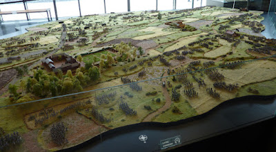
The museum is wonderful, and from a cynical old warhorse like me this is high praise. Here are a few views of the big model in the entrance hall; I feel I did well to move on from this quite early - I have been known to lose days of my life staring at this sort of thing
Now we are into the main museum displays...
I don't know what this is, but I like it. Random knick-knack in the entrance to one of the restaurants at the museum site
Demonstration of firing a cannon; this chap, who was the main presenter for the Anglophones, is dressed as a drummer in the Belgian light infantry, but he was very handy at firing a cannon, and certainly knew his stuff in the history department. I have to confess that I am still not absolutely certain which country the battlefield was in in June 1815, or why, but am happy to accept that it was a Belgian bit of Holland. There is a counter-theory that it might have been Sort-Of-France, but we dismissed this since Wellington was ordered to stay out of France
The Panorama in the Rotunda building is impressive, of course, but it doesn't photograph too well. Here is the best known bit, with Ney and his chums leading the Grand National
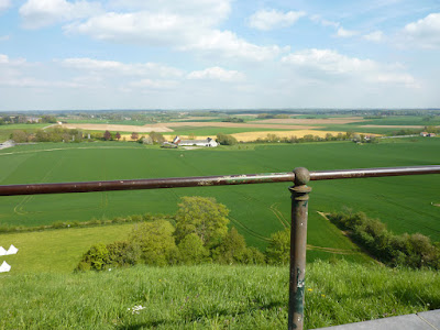
It goes without saying that we were obliged to climb up the Lion Mound, because we were British and it was there. Since my conversion to varifocals, I have significant vertigo problems in high places. The Lion is not so high, but the steps are dead straight, in one flight, and polished to a suitable military shine. I was tempted to bow out of the climb, but I would have been ashamed if I had done so, and so I whimpered my way up and down, and am very grateful to my colleagues for not pushing me over the bannister. From the top you can get a view of La Haye Sainte

After lunch, we pushed on to the main Brussels-Charleroi road (which is very, very busy), and followed a concrete cycle track alongside the road, past La Haye Sainte, heading south towards La Belle Alliance. We were all struck by the extent to which the ridges and dips in the fields must have affected visibility. For a start, you cannot see La Haye Sainte at all from Hougoumont - it's beyond a low ridge - that was a surprise. Troops moving on the field within a short distance must often have been concealed from each other, which certainly explains a few of the mistakes which occurred. Another mild shock was the size of the field; it may be a small battlefield, considering the date and the number of troops involved, but it looks far larger than I expected

When we got near to La Belle Alliance, we began to get uncertain just where the French grand battery was placed. It looks like a no-brainer when you are looking at it from the Allied lines, but we eventually decided it was one ridge further back than we expected - here you see a clue
Belle Alliance itself is a working night club, obviously maintained continuously since 1815, and thus not very interesting. Attached to the west wall is this little plaque to the French medical services
Then we headed east up the road to Plancenoit, which is a prosperous little town, obviously expensively rebuilt since 1815. Here's the church of St Catherine, which was rebuilt after the battle, using the original materials as much as possible. We thought the spire had been changed during the rebuild
Pretty town, Plancenoit - here's the square, looking across from the church
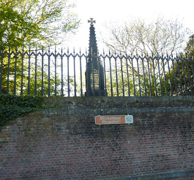
Although it is very close to the church, the Prussian monument took a little finding. It seems that, in the years around 1815, the place where it stands was a bald hill, on the northern edge of the village, from whence the Prussians made their repeated attacks against the church area
I thought this was interesting; this site must have been fields just north of Plancenoit village. If Milhaud's cuirassiers started their advance from here to fight the Allied squares, they came from a long way back
Here you see a sunset view of the Lion Mound as we passed by on our way back to Braine l'Alleud
The sun was starting to sink, and we had a lengthy march (for us, anyway) back across country to La Belle Alliance, and then along a diagonal track back up toward the Lion. We bought sandwiches from an Esso garage on the Chaussée de Nivelles in Braine l'Alleud, and discussed our plans for Day 3.


Now the sore foot starts to make sense! You all covered a fair few kilometres on day 2
ReplyDeleteIt was my own fault, sergeant. I was wearing some new (but broken-in) Seibel boots, and on Day 2 I put on the heavy duty serious-walking "Bridgedale" socks, but I reckoned I'd get away without the liners. You know sometimes you make a decision that you swear about afterwards? I was OK, in strategic terms, since I applied half a pack of Compeed plasters, but it was the sort of mistake that only Raw troops would make; well, allocate me triple retreats and pass the brandy - tell my mum I died for Liverpool.
DeleteVery interesting Tony. I think most of us reading this blog could easily spend half our lives looking at that diorama. Rather like players of 'Better than Life' in Red Dwarf.
ReplyDeleteYour comments about visibility and scale of the battlefield show the importance of 'walking the ground'. Our flat tabletops and vertically out of scale models create misleading impressions.
The diorama is very large, of course (technical term used by diorama builders), but the infantry battalions seem to be 40 figures, so there is still some scaling here. My 8-year-old brain kept thinking, "what a fantastic table for a miniatures game", while my heavy-adult 9-year-old brain was concerned about whether trapdoors or hoists would be best to reach the middle, and my OCD 10-year-old brain was horrified at the job required to tidy up at the end, and put the troops back into their starting positions.
DeleteWhether or not to remove casualties - now there's a question...
Hmm, wait, seems to me the diorama builders have understated the number of soldiers in a battalion and.......... Damned impressive and mesmerizing though!
ReplyDeleteI do have a fondness for the Lion Mound, largely because 50 years ago I dragged my reluctant (ie horrified if not terrified of being arrested ) travelling companion through the hedge to roll out our sleeping bags at the foot of the mound.
Agree - it's very impressive indeed. My point about the scaling is merely that I don't know if anyone has ever attempted a full 1:1 model of a battlefield - did Siborne go full scale like this?
DeleteThe Mound has an odd folk-lore reputation. Our host told me a tale of young people leaving their clothes at the bottom and taking a bottle to the top for the night. Sort of a rite of passage?
It is a while since I've seen Sibornes diorama, but my recollection is that the battalions were quite large. According to Wikipedia his is done at 1:2 with 75,000 figures.
DeleteThanks Martin - I didn't know that. Interesting.
DeleteAnother fantastic day, what a great way to spend a few days with a group of like minded friends!
ReplyDeleteAbsolutely - I can't remember any disappointments or things which didn't work out, once we'd landed safely at Charleroi.
DeleteBrilliant, I’d have had to be dragged away from the diorama! When we did our demo games we always tried to make sure we walked the battlefield, it’s amazing the difference between interpreting an OS map and looking at photos to actually walking it as you say small folds and gentle slopes take on a whole new significance. Roll on day 3
ReplyDeleteThe terrain thing was quite an eye-opener. I suppose I was aware of it, but it really hits you in the nose when you are there.
DeleteWaterloo is on my bucket list.
ReplyDeleteIn modern parlance "well - jell".
I had to look the phrase up, but thanks for this. I believe this is my first bit of genuine Essex vocabulary!
DeleteIt is a rich culture down here!
Delete