For our last full day, the objective was to go into Waterloo itself, a few miles north of the battlefield, to check out the Wellington Museum and the church opposite. Getting there was easy - we scrounged a lift, which was very useful!
After our military investigations, we had an excellent lunch in a terrace cafe in Waterloo, then caught the bus back to Braine l'Alleud and walked past the Lion and La Haye Sainte, along the Allied line, to have a look at the farm at Papelotte.
As in the previous instalments, I'll try to build an outline narrative in the captions to the pictures.
The Wellington Museum in Waterloo; Wellington made his HQ in the hotel in the village. I believe this photo shows his bedroom, and his bed, in which his ADC, Alexander Gordon, died after the battle. The soldier is an officer of the 42nd Foot; what he's doing there is unknown to me
Wellington at his desk, writing his report of the victory. The decor of the room includes a portrait of himself, over the fire, which seems like vanity, and in the window there is a bust of him about 30 years later, which is downright weird
The Museum has all sorts of exhibits - here are some Allied soldiers
I assume this is genuine, and they pinched it off the wall of the Belle Alliance inn, later night club
Back in the weird department; this is one of Lord Uxbridge's prosthetic legs, which obviously postdates the battle. Unless, of course, the correct quote was, "My God, sir, I've lost my wooden leg..."
For those with uneasy memories of wobbling up the Mound, here it is in Lego - there is no escape
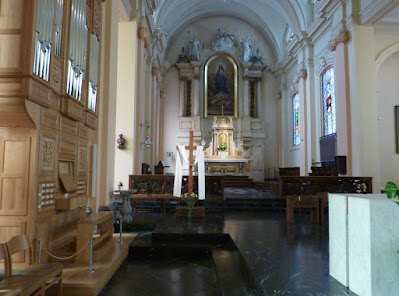
Directly opposite the Museum is the church. The domed structure at the front was built later than the battle. In 1815, most of the main street of the village appears to have been wooded
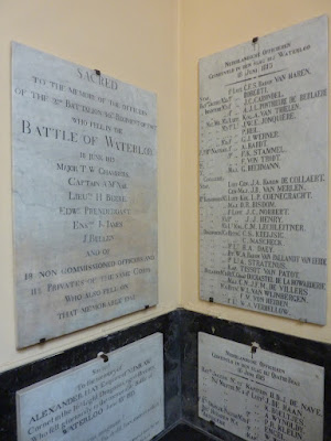
Inside the church is a remarkable collection of British memorials; these are worth a study in themselves
In passing, I observe the memorial to Alexander Hay, of Nunraw, which place is up in the hills above the East Lothian village of Garvald, about 10 miles from where I am sitting typing this
My last picture of Waterloo, the town, is a view of the Wellington Museum, taken from the church steps
OK - after our lunch, and a bus ride back to the battlefield, we set off along the ridge line, east towards Papelotte. Here we have just started; we are a short distance along from the crossroads, La Haye Sainte is just the other side of the clump of trees on the right, which are close to the site of the sandpit. At this point the crest of the ridge is just in front of us, but you can see how much undulation there is in the valley ahead. The grand battery is somewhere on the green ridge in the distance
Another French monument; if you can make out the text, it becomes apparent the word "héroiquement" is one of a series of euphemisms which mean "unsuccessfully"
We are looking across towards Plancenoit here
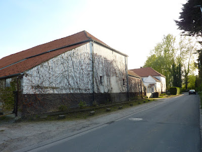
This is Papelotte Farm. The present buildings are all later than 1815 (I think the place was destroyed); we are south of the farm buildings, and the lane is sloping back up towards the main Allied ridge line
More of Papelotte - again, we are on the French side of the buildings
From this point, the view south towards Plancenoit has an uphill slope, and the terrain to the east changes abruptly into something like bocage - hills, twisty lanes with steep banks - very different to the main battlefield
We followed the lane south from Papelotte, the Chemin de Marache. We were trying to get to the battlefield locations of La Haye and Fichermont, which are marked on the old maps, to the south-east of Papelotte, and close to it.
First interesting fact was that we read that the chateau of Fichermont was destroyed years ago, and its remains have been buried under the roots of a wood. OK - we'll just look for evidence of the name, then. Second interesting fact was that it turns out that Marache is the modern name of Smohain, which place is definitely on the old battlefield maps. The next few photos, then, are of the village which used to be Smohain
Fichermont may not exist, but here's a lane that used to go there!
Now we have turned west, on the Route de Marache, and are leaving the village, which should take us past La Haye (wherever that is) and back to the end of the lane up to Papelotte
We pass a serious looking farm, which is too modern for 1815, and is on the wrong side of the lane to be La Haye...
...here's the big house and the front gate...
...but here, opposite, on the other side of the lane, is a house which is also too modern, and is now a Gingko Centre or something - but this building appears to be on the site of La Haye, so we (sort of) found it! Continuing along the lane to the west, in about 50m we came back to the lane end at Papelotte, so we had completed our loop
That is all my photos for this trip. The following day we were fully engaged in travelling to Brussels and catching a plane home - Brussels Airways this time - so my camera was safely locked away in my luggage.
A couple of thoughts.
We spent a lot of time during our stay discussing the detail of the terrain. There has been much surmise and legend over the years about the significance of the ground conditions at Mont St Jean. We observed, even in the fine weather which blessed our visit, that the fields at the bottom of the shallow valley between the French and Allied positions were distinctly marshy in places, you could see it to the east of the main road, near La Belle Alliance. In really wet weather, it looks as though it might have been a problem for moving artillery, and D'Erlon's boys would be fairly squelching along in the low ground.
The Archduke, looking at the diorama in the Battlefield Museum, asked a very interesting question. It does seem odd that the French army committed so much time and effort to banging their heads against Hougoumont. If Napoleon really wanted to "tease" the Allied right, why didn't he just bypass Hougoumont and swing around it? It would be interesting to know how Wellington would have reacted, in view of the implied threat of a push towards Hal, and maybe Ghent, jeopardising the British line of retreat to Ostende.
For me, Hougoumont is a puzzling bit of the battle anyway; did Napoleon simply give the order to attack, and forgot to tell them when to stop? Quite a lot of the French strategy on the big day looks very like wishful thinking.


That is very interesting. I've seen so many wargames of Waterloo where the ridges are the equivalent of precipitous mountains, but those slopes really are quite gentle.
ReplyDeleteEspecially if the rye and wheat of the day were 6ft high, the visibility must have been very uncertain. The slopes are gentle on the main battlefield, as you say, but the undulations (is that the word?) are deceptive.
DeleteA fantastic final episode, thanks for sharing a trip I very much doubt I will ever make myself.
ReplyDeleteI've previously considered going with an organised tour - I believe some of them are very highly rated. Very highly geared - if you don't like, or disagree with, the tour guide then that is an irritant, and I would worry about sharing a bus for a few days with people like me...
DeleteThis arrangement, going along with a couple of friends, where we all did a pile of reading before we went, and we could set our own pace, was fine.
Thanks for bringing us along on the tour!
ReplyDeleteThank you for coming, Ross. Keep me posted on how your feet are recovering; mine are coming along nicely!
DeleteI once met a man with a wooden leg called Paget.
ReplyDeleteI knew a man with a wooden leg too. I called him Grandpa.
DeleteExtraordinary - that's a real coincidence, and it is, let's face it, a very unusual name for a leg.
DeleteTony, I sure enjoy seeing the battlefield through your eyes and lense. Thank you for taking the time to snap some photos and provide interesting commentary. Like you, I like studying the lay of the land when i am walking a battlefield. I am off today to walk a few battlefields myself.
ReplyDeleteThank you, my friend, for your stamina. Hope you have an excellent day Jon. Battlefields always surprise me - I have very little natural talent for judging space and distance, so I am always surprised by the layout of a real fight. This is certainly why I would have been a terrible general, once they had invented the bow and arrow, and probably why I was a lousy footballer!
DeleteFirst, I fly overnight covering about 3,000 miles before my adventures can begin.
DeleteRight - that's serious commitment. Have a good trip. I'm confident that you will not be travelling by Mickey's and Goofy's Air Services, which is one mistake we made!
DeleteA great write-up Tony and excellent photos. You certainly covered a lot of ground and got much further than I ever did. As you mention, the undulations in the landscape particularly in the area between Hougoumont and La Haye Sainte, need to be seen to be appreciated. Also, the distance between the two farms seems huge and yet accounts say that during Ney's attacks it was completely filled with French cavalry - must have been quite a sight!
ReplyDeleteThanks Ian - we had more time, and greater unity in our sense of mission! One thing that becomes clear is that the famous incidents of battalions being ordered to march into cuirassiers were probably because the officers couldn't see the enemy, though they were close by.
DeleteWe were very impressed by the 3-D movie at the main battlefield museum - I think I lost an ear in the cavalry charge. The film was advertised as "4-D" - I can't think what that would mean, unless we actually watched the following day's performance.
Cracking conclusion and some very interesting photos, interesting re the changing terrain as you moved further away from the centre. Likewise re the ground conditions in the dips in the ground.
ReplyDeleteThe Waterloo museum looks ‘quaint!’ 🙄. Glad you had a good time
Had a great time, Graham, and learned a lot (though remembering it may be a further challenge). Hope you get there sometime soon.
DeleteA very interesting series of articles Mr. Foy, i've enjoyed them thoroughly, it's facinateing how little has changed, yet how much has changed, if you know what I mean, and the shots of the undulating ground are very interesting, I know from experience now much harder it is to judge distance when you have all that dead ground and false horizons! Nowadays, you work off the pylons, street lights, road markers and telegraph poles and ignore the lie of the land, not always a given in the sticks!
ReplyDeleteH
Thank you Hugh. Another thing that interested me is the effect of farming on the landscape. I'm not sure how the land was for hedges or formal field margins in 1815, but I live on a farm, and I observe the changes here. Admittedly we now have automated ploughing and harrowing, but the effect of decades of repeating work, plus weather erosion, is that the fields tend to level out a bit, and you get a terracing effect at the edges of the fields.
DeleteOne pretty dangerous aspect of our trip was walking along the cycle track alongside the Charleroi chausée - not sure why, but all the bikes came from behind us, and we couldn't hear them. [Charleroi must be filling up with bicycles...]
Hurrah!… It now appears I can post on your blog Tony…
ReplyDeleteWhat a splendid break… I am of course very jealous.
All the best. Aly
Hi Aly - welcome back. I missed you, man. The trip could hardly have gone any better - I must be due a stinker next time.
DeleteI have really enjoyed poring over your three posts, looks like it was a great trip with plenty to see, many thanks for posting your trip photos and descriptions, really interesting.
ReplyDeleteThanks Donnie - it was great to be back in That Europe again. I had plenty of time in my 4 leisurely treks through Passport Control to relish our new-found Sovereignty. No offence to our new King, but what a bloody embarrassment the whole set-up is.
DeleteExcellent stuff, thank you for sharing, and glad you had such a successful trip!
ReplyDeleteThanks David
DeleteCushty (My final "learning you Essex" - I promise!)
ReplyDeleteI like it. As they say in Liverpool, "Sound".
Delete